Plaquemines Parish Coastal Erosion
Louisiana Coastal Erosion
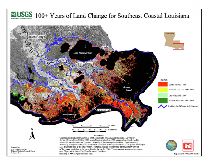
Louisiana contains 30% of the total marshland within the lower 48 U.S. states, but unfortunately leads in coastal erosion and wetland loss, making up 90% of coastal marsh loss. Currently Louisiana has lost 1,900 square miles since the 1930's and continues to lose an estimated 70 square kilometers/year, or a football field of land every 38 minutes, due to a combination of natural processes, such as storms, sea-level rise, and subsidence, as well as man made alterations to the Mississippi River and wetlands over the past 200 years, i.e. the construction of levees and canals, and the development of the oil and natural gas industry. Hurricanes Katrina and Rita alone converted 217 square miles of marsh to open water in coastal Louisiana. If the current rates continue, an estimated 500 square miles will be lost within the next 50 years. Being that nearly 30% of the nation's fisheries and 25% of the nation's oil and natural gas come from Louisiana wetlands, these significant losses in coastlines can have detrimental effects. Not only are these changes important for the nation as a whole, but also to the 2 million residents who call this area home.
Coastal erosion of southeast Louisiana over a 100 year period. Red shows land loss from 1932-2000, yellow shows predicted land loss from 2000-2050, light green shows land gain from 1932-2000, and dark green shows land gain from 2000-2050
Coastal erosion of southeast Louisiana over a 100 year period. Red shows land loss from 1932-2000, yellow shows predicted land loss from 2000-2050, light green shows land gain from 1932-2000, and dark green shows land gain from 2000-2050
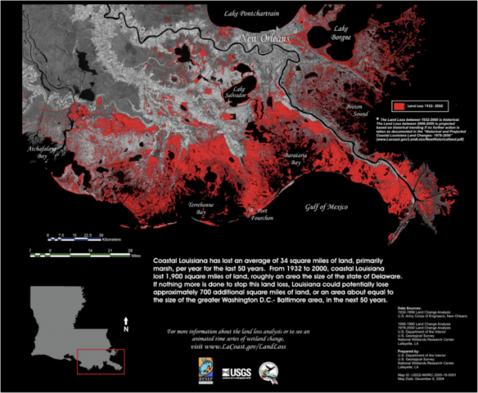
To further add to the significance of this loss, Louisiana wetlands support 1.8 million migratory waterfowl, as well as a $38 million alligator industry and a $1.75 million fur industry. Louisiana wetlands also serve to protect the 15 largest ports in the U.S. that carry nearly 457 million tons of waterborne commerce, making up 18% of all waterborne commerce in the United States. Commercial fisheries bring in around $202 million, while recreational fishing accounts for $1.7 billion and hunting $975 million. Most strikingly, Louisiana ranks first in crude oil and second in natural gas production. As can be seen, the Louisiana wetlands hold importance and value for a number of different reasons, and should be protected to avoid detrimental effects on a mass scale.
For more information visit http://www.nwrc.usgs.gov/wetlands.htm and http://dnr.louisiana.gov/crm/coastalfacts.asp.
For more information visit http://www.nwrc.usgs.gov/wetlands.htm and http://dnr.louisiana.gov/crm/coastalfacts.asp.
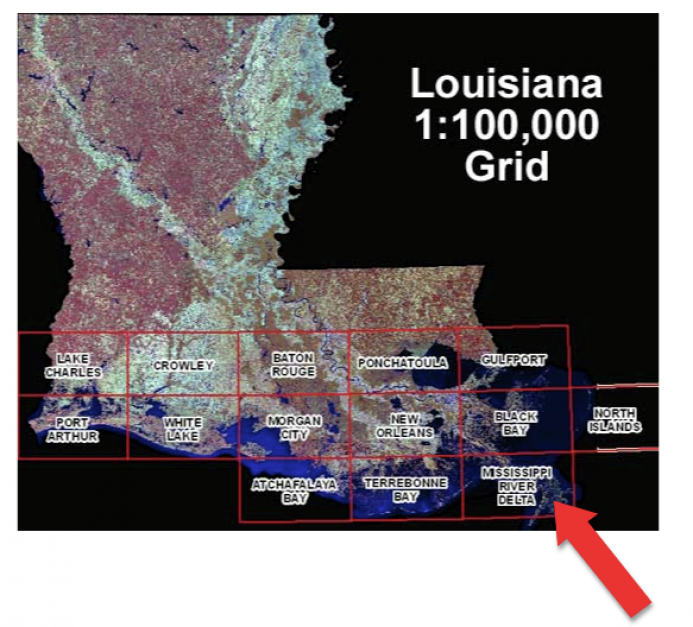
The red arrow on the diagram to the left shows the approximate location of Plaquemines Parish, which is only a portion of the Mississippi River Delta. The Louisiana delta region was formed approximately 6,000-7,000 years ago due to major changes in river channels, major floods and storms, normal flood and storm events, and daily tides. The Mississippi Deltaic Plain is only one portion of Louisiana experiencing the effects of coastal erosion and makes up approximately 25,000 square kilometers. The following page gives background information on the specific area of the Mississippi Delta region studied--Plaquemines Parish.
